

This article first appeared on Grist.org.
“It doesn’t matter how many thermographers we have, boots on the ground, satellites flying in the air, people with drones and airplanes and all the other technology, none of it matters if you don’t stop methane. None of it counts.”
Sharon Wilson, “methane hunter” and director of Oilfield Witness
Back when I worked with satellites (my career before journalism), and I’d talk about my job with folks from outside the space industry, they often responded simply, “Oh, cool.” It always struck me that, though satellites in many ways enable modern life, many people still think about space tech in terms of astronauts and other worlds. But satellites are what make GPS, weather forecasting, long-distance communication, and even airplane Wi-Fi possible. And a growing fleet of precision satellites are now enabling climate solutions, too: helping us spot, and stop, pollution.
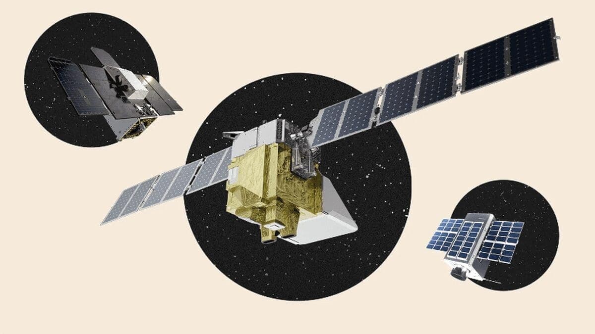
Two weeks ago, a satellite designed to identify, measure, and monitor greenhouse gas emissions worldwide was launched into orbit by SpaceX. The spacecraft, called Tanager-1, is a collaboration between NASA’s Jet Propulsion Laboratory, the Earth-imaging company Planet Labs, the environmental nonprofit Carbon Mapper, and others. Tanager-1 has now joined 23 other satellites on orbit, operated by a mix of organizations and agencies, all capable of detecting the potent greenhouse gas methane — which, for the first 20 years after it’s emitted, warms the planet 80 times faster than the same amount of CO2.
Naveena Sadasivam and I recently reported on this new wave of methane-monitoring satellites, and as part of that reporting, we had the chance to speak with Riley Duren, the CEO of Carbon Mapper. Duren previously worked as the chief systems engineer for the Jet Propulsion Laboratory’s Earth science division where he pushed to establish a climate research portfolio, which included expanding the lab’s ability to monitor greenhouse gases. He knew this monitoring could help mitigate climate change, not just study it.
“You can’t manage what you don’t measure,” Duren said.
Carbon Mapper itself emerged in 2020 as a “spin-off,” Duren said, of the work he and others at the lab were doing to study the sources of methane emissions from planes, identify the worst offenders, and alert them so that the operators could take action to fix the leaks that the researchers spotted. While they’d had much success with these aerial surveillance campaigns, “to do it in a sustained and operational way,” Duren said, “we needed satellites.”
But government agencies had no plans to build and launch satellites of that kind, so Duren started chatting with climate philanthropists to put together the funds that would allow him and Carbon Mapper to create their own spacecraft.
Tanager-1, and the flock of similar satellites that Carbon Mapper plans to launch, will work alongside another nonprofit mission that launched earlier this year, MethaneSAT, to better understand where the highest-value actions can be taken to quell methane emissions and leaks. Duren used a metaphor of photographing birds to describe how the satellites can support each other’s efforts to monitor methane. MethaneSAT provides the equivalent of a landscape view, and can point out where there’s a flurry of bird activity. Tanager-1 can then zoom in and capture telephoto snapshots of the metaphoric birds and nests. “And because Carbon Mapper’s flying a constellation of satellites,” Duren said, “it’s kind of like an army of birdwatchers that are going out to follow up on what the landscape photographer has drawn everyone’s attention to.”
Below is an excerpt of the feature I co-wrote with Naveena, covering the highly anticipated launch of MethaneSAT in March, and the hopes and worries of those watching. You can find the full feature here, if you want to read more about the history of using satellites to monitor greenhouse gas emissions, what this new fleet offers, and what opportunities researchers hope to open up with this new and improved tech.
On a blustery day in early March, the who’s who of methane research gathered at Vandenberg Space Force Base in Santa Barbara, California. Dozens of people crammed into a NASA mission control center. Others watched from cars pulled alongside roads just outside the sprawling facility. Many more followed a livestream. They came from across the country to witness the launch of an oven-sized satellite capable of detecting the potent planet-warming gas from space.
The amount of methane, the primary component in natural gas, in the atmosphere has been rising steadily over the last few decades, reaching nearly three times as much as preindustrial times. About a third of methane emissions in the United States occur during the extraction of fossil fuels as the gas seeps from wellheads, pipelines, and other equipment. The rest come from agricultural operations, landfills, coal mining, and other sources. Some of these leaks are large enough to be seen from orbit. Others are miniscule, yet contribute to a growing problem.
Identifying and repairing them is a relatively straightforward climate solution. Methane has a warming potential about 80 times higher than carbon dioxide over a 20-year period, so reducing its levels in the atmosphere can help curb global temperature rise. And unlike other industries where the technology to decarbonize is still relatively new, oil and gas companies have long had the tools and know-how to fix these leaks.
MethaneSAT, the gas-detecting device launched in March, is the latest in a growing armada of satellites designed to detect methane. Led by the nonprofit Environmental Defense Fund, or EDF, and more than six years in the making, the satellite has the ability to circle the globe 15 times a day and monitor regions where 80 percent of the world’s oil and gas is produced. Along with other satellites in orbit, it is expected to dramatically change how regulators and watchdogs police the oil and gas industry.
“Companies do a good job of complying with the law, but the law has been insufficient,” said Danielle Fugere, president and chief counsel at As You Sow, a nonprofit group that has used shareholder advocacy to push fossil fuel producers to tackle climate change. “So this change will increase incentives for reducing methane emissions.”
Those at Vandenberg or watching online were a bit on edge. A lot could go wrong. The SpaceX rocket carrying the satellite into orbit could explode. A week before, engineers worried about the device that holds the $88 million spacecraft in place during launch and pushes it into space. “That made us a little nervous,” recalled Steven Wofsy, an atmospheric scientist at Harvard University and a key architect of the project along with Steven Hamburg, the scientist who leads MethaneSAT at EDF. If that didn’t go wrong, the satellite could still fail to deploy or have difficulty communicating with its minders on Earth.

They needn’t have worried. A couple hours after the rocket blasted off, Wofsy, Hamburg, and his colleagues watched on a television at a hotel about two miles away as their creation was ejected into orbit. It was a jubilant moment for members of the team, many of whom had traveled to Vandenberg with their partners, parents, and children. “Everybody spontaneously broke into a cheer,” Wofsy said. “You [would’ve] thought that your team scored a touchdown during overtime.”
The data the satellite generates in the coming months will be publicly accessible — available for environmental advocates, oil and gas companies, and regulators alike. Each has an interest in the information MethaneSAT will beam home. Climate advocates hope to use it to push for more stringent regulations governing methane emissions and to hold negligent operators accountable. Fossil fuel companies, many of which do their own monitoring, could use the information to pinpoint and repair leaks, avoiding penalties and recouping a resource they can sell.
Regulators could use the data to identify hotspots, develop targeted policies, and catch polluters. For the first time, the Environmental Protection Agency is taking steps to be able to use third-party data to enforce its air quality regulations, developing guidelines for using the intelligence satellites like MethaneSAT will provide. The satellite is so important to the agency’s efforts that EPA Administrator Michael Regan was in Santa Barbara for the launch as was a congressional lawmaker. Activists hailed the satellite as a much-needed tool to address climate change.
“This is going to radically change the amount of empirically observed data that we have and vastly increase our understanding of the amount of methane emissions that are currently happening and what needs to be done to reduce them,” said Dakota Raynes, a research and policy manager at the environmental nonprofit Earthworks. “I’m hopeful that gaining that understanding is going to help continue to shift the narrative towards [the] phase down of fossil fuels.”
With the satellite safely orbiting 370 miles above the Earth’s surface, the mission enters a critical second phase. In the coming months, EDF researchers will calibrate equipment and ensure the satellite works as planned. By next year, it is expected to transmit reams of information from around the world. Its success will depend on the quality of the data it can produce and — perhaps more importantly — how that data is put to use.
The European Space Agency released the first global measurements of atmospheric methane three years after launching the Environmental Satellite, or Envisat, in 2002. In 2009, three years before the Envisat mission ended, Japan’s Greenhouse Gases Observing Satellite, or GOSAT, made its orbital debut. These early progenitors established a new era of worldwide emissions accounting, but they lacked the geographic precision required to inform meaningful action.
In the years since, a hodgepodge of governmental agencies and private-sector organizations has deployed 23 more satellites, including MethaneSAT, to glean additional insights. Some improved upon the pioneering technology by mapping global emissions with greater fidelity and surveying the world with what one could call a wide-angle view. But most measure emissions in targeted areas with what amounts to a telephoto lens.


The images they collect, however, are nothing like what a Nikon might capture, because methane, like most gases, is invisible to humans. So these satellites rely on a spectrometer to reveal the infrared signature the gas leaves behind, exposing not only its presence, but its concentration.
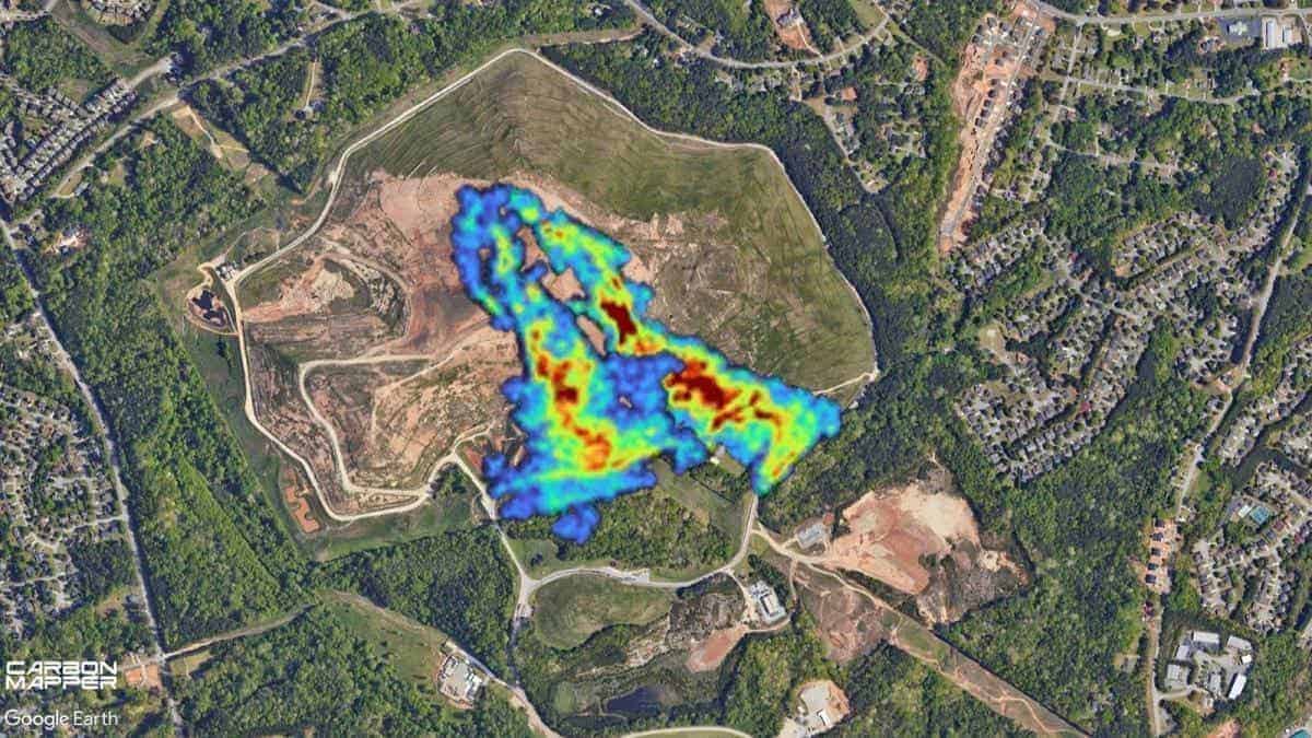
How large a chunk of the world a satellite can map, and the resolution it can provide, depends primarily upon the magnifying power of its telescope. Typically, a higher magnification allows the examination of smaller areas in greater detail, while a lower magnification is best for analyzing vast areas in less detail. The instruments aboard each satellite have all been designed with a unique combination of sensitivities and resolutions tailored to its primary mission.
Given GOSAT, for example, was designed to track methane and greenhouse gas concentrations over the entire planet in coarse resolutions, it would have no trouble measuring methane emissions across Southern California and beyond, but it would condense Santa Monica into a single pixel. On the other hand, with the privately owned GHGSat focused on taking images of precise areas and identifying the facilities responsible for emissions, its satellites could map the city of Santa Monica in exquisite detail and pinpoint a sizable methane leak to within 80 to 160 feet, but would struggle to provide any indication of what’s happening beyond the city.
EDF saw an opportunity to create a satellite capable of doing both by designing MethaneSAT’s instrument to take images that cover 125 miles of Earth’s surface, enough to capture most of an oil field spanning dozens of miles in a single frame with sufficient resolution to identify small groups of wells and other infrastructure within that expanse. The nonprofit and its researchers began to see the need for such a device about a decade ago, at the height of the fracking boom. The organization was coordinating the work of hundreds of scientists who “were creating more data about methane emissions from the oil and gas industry in the U.S. than anyone had,” Hamburg said, “by orders of magnitude.”
EDF flew spectrometers aboard airplanes over oil fields, and discovered that the EPA had severely underestimated the amount of methane emitted by oil and gas operations. Although these studies proved invaluable, the scientists couldn’t conduct these labor-intensive, aerial campaigns at the scale or frequency required to understand global methane emissions and how they evolved. That piecemeal approach made clear that no one understood the extent of the problem. Even for the areas they could image, “you’re getting snapshots,” Hamburg said, “but not a motion picture.”
Hamburg and his colleagues set out to determine what it would take to monitor the world’s most productive oil fields on a near-daily basis to determine where, and how much, methane escaped and how those emissions were changing over time. “We’d done enough looking,” Hamburg said, “that we didn’t think the existing satellites or the planned satellites were going to provide that data.”
More exposure
- Read: more about the recent launch of Carbon Mapper’s Tanager-1 satellite (Scientific American)
- Watch: a short video describing the workings of MethaneSAT since its launch in March, and some of the initial images the satellite has transmitted (Environmental Defense Fund)
- Read: about the latest data on the problem of methane leaks from oil and gas infrastructure, and how satellites will help deliver a clearer picture (MIT Technology Review)
- Read: about how much methane comes from landfills — and why composting could offer a solution (Grist)